南京大学学报(自然科学版) ›› 2024, Vol. 60 ›› Issue (2): 209–217.doi: 10.13232/j.cnki.jnju.2024.02.003
• • 上一篇
青藏高原东部地形对四川盆地东北部一次暴雨过程的影响
艾真珍1,2, 董寅硕2, 徐昕1( ), 季玉枝1, 衡志炜3
- 1.中尺度灾害性天气教育部重点实验室,南京大学大气科学学院,南京,210023
2.南京信息工程大学,南京,210044
3.中国气象局成都高原气象研究所,高原与盆地暴雨旱涝灾害四川省重点实验室,成都,610072
Effect of topography of eastern Qinghai⁃Xizang Plateau on a rainstorm occurred in northeastern Sichuan Basin
Zhenzhen Ai1,2, Yinshuo Dong2, Xin Xu1(), Yuzhi Ji1, Zhiwei Heng3
- 1.Key Laboratory of Mesoscale Severe Weather,Ministry of Education,and School of Atmospheric Sciences,Nanjing University,Nanjing,210023,China
2.Nanjing University of Information Science and Technology,Nanjing,210044,China
3.Institute of Plateau Meteorology,CMA,Heavy Rain and Drought?Flood Disasters in Plateau and Basin Key Laboratory of Sichuan Province,Chengdu,610072,China
摘要:
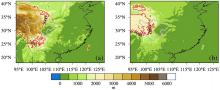
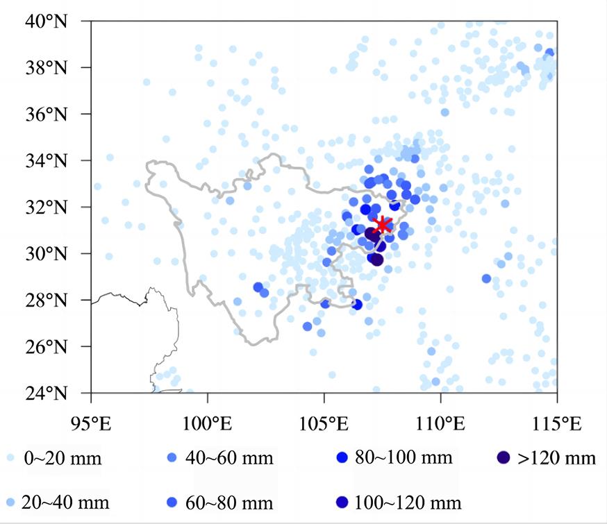
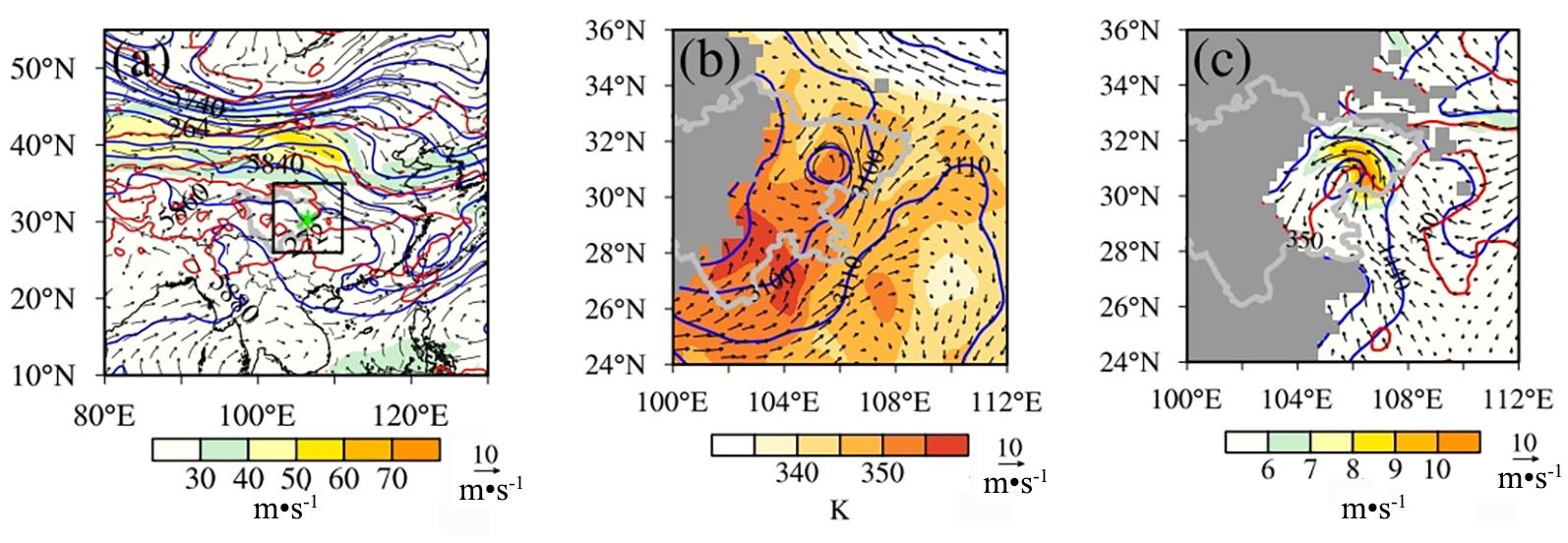
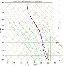
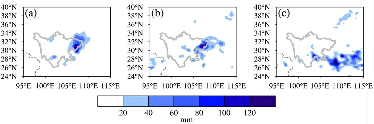
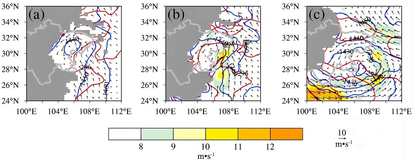
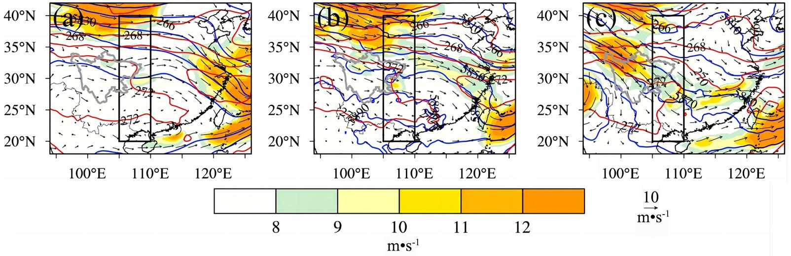
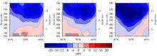
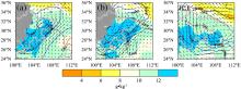
针对2021年8月8日发生在四川盆地东北部的一次暴雨,利用地面观测和再分析资料,结合WRF (Weather Research and Forecasting)敏感性数值试验,研究了青藏高原东部地形对本次暴雨过程的影响和机理.结果表明,暴雨发生期间四川盆地主要受500 hPa高压脊影响,青藏高原东南侧绕流形成的西南气流向暴雨区输送暖湿空气,并在盆地形成低涡.高低空系统的耦合使得气流辐合抬升,为暴雨发生提供了良好条件.当青藏高原东部地形高度降低以后,地形对气流的阻挡作用减弱,原先高原东南侧绕流产生的西南气流减弱变为偏西气流.同时,高原东北侧的西北气流加强并南下,进一步减弱四川盆地的南风分量和水汽输送,最终导致水汽在四川盆地东南侧聚集和暴雨落区的南移.
中图分类号:
- P445


| 1 | Spreen W C. A determination of the effect of topography upon precipitation. Eos,Transactions American Geophysical Union,1947,28(2):285-290. |
| 2 | Danard M. A simple model for mesoscale effects of topography on surface winds. Monthly Weather Review,1977,105(5):572-581. |
| 3 | Basist A, Bell G D, Meentemeyer V. Statistical relationships between topography and precipitation patterns. Journal of Climate,1994,7(9):1305-1315. |
| 4 | 朱民,余志豪,陆汉城. 中尺度地形背风波的作用及其应用. 气象学报,1999,57(6):705-714. |
| Zhu M, Yu Z H, Lu H C. The effect of meso?scale lee wave and its application. Acta Meteorologica Sinica,1999,57(6):705-714. | |
| 5 | 廖菲,胡娅敏,洪延超. 地形动力作用对华北暴雨和云系影响的数值研究. 高原气象,2009,28(1):115-126. |
| Liao F, Hu Y M, Hong Y C. Numerical study for the influences of orographic dynamic on cloud and precipitation in North China. Plateau Meteorology,2009,28(1):115-126. | |
| 6 | 陈明,傅抱璞,于强. 山区地形对暴雨的影响. 地理学报,1995,50(3):256-263. |
| Chen M, Fu B P, Yu Q. Influence of topography on storm rainfall. Acta Geographica Sinica,1995,50(3):256-263. | |
| 7 | 段海霞,刘新伟.喇叭口地形对一次暴雨影响的数值试验.干旱气象,2009,27(4):327-333. |
| Duan H X, Liu X W. Numerical experiment of trumpet?shaped topography influence on a heavy rain.Journal of Arid Meteorology,2009,27(4):327-333. | |
| 8 | 王沛东,李国平. 秦巴山区地形对一次西南涡大暴雨过程影响的数值实验. 云南大学学报(自然科学版),2016,38(3):418-429. |
| Wang P D, Li G P. Numerical experiments of the impact of Qin?Ba Mountainous terrain on a rainstorm caused by southwest vortex. Journal of Yunnan University (Natural Sciences Edition),2016,38(3):418-429. | |
| 9 | 毕宝贵,刘月巍,李泽椿. 秦岭大巴山地形对陕南强降水的影响研究. 高原气象,2006,25(3):485-494. |
| Bi B G, Liu Y W, Li Z C. Study on influence of the mechanical forcing of mesoscale topography on the extremely heavy rainfall in southern Shaanxi on 8-9 June 2002. Plateau Meteorology,2006,25(3):485-494. | |
| 10 | 李萍云,王楠,戴昌明,等. 一次秦岭南麓暴雨中秦巴山区地形作用模拟分析. 陕西气象,2018(1):1-9. |
| 11 | 陈志昆,张书余. 地形在降水天气系统中的作用研究回顾与展望. 干旱气象,2010,28(4):460-466. |
| Chen Z K, Zhang S Y. Review and outlook of landform influences on rainfall weather systems. Journal of Arid Meteorology,2010,28(4):460-466. | |
| 12 | 李国平. 青藏高原动力气象学. 第3版. 北京:气象出版社,2021,82-88. |
| 13 | 康慕谊,朱源. 秦岭山地生态分界线的论证. 生态学报,2007,27(7):2774-2784. |
| Kang M Y, Zhu Y. Discussion and analysis on the geo?ecological boundary in Qinling range. Acta Ecologica Sinica,2007,27(7):2774-2784. | |
| 14 | Son J H, Seo K H, Wang B. How does the Tibetan Plateau dynamically affect downstream monsoon precipitation? Geophysical Research Letters,2020,47(23):e2020GL090543. |
| 15 | 何钰,李国平. 青藏高原大地形对华南持续性暴雨影响的数值实验. 大气科学,2013,37(4):933-944. |
| He Y, Li G P. Numerical experiments on influence of Tibetan Plateau on persistent heavy rain in South China. Chinese Journal of Atmospheric Sciences,2013,37(4):933-944. | |
| 16 | 梁玲,李跃清,胡豪然,等. 青藏高原夏季感热异常与川渝地区降水关系的数值模拟. 高原气象,2013,32(6):1538-1545. |
| Liang L, Li Y Q, Hu H R,et al. Numerical study of influence of sensible heat anomalies in summer over Qinghai?Xizang Plateau on rainfall in Sichuan?Chongqing regions. Plateau Meteoro?logy,2013,32(6):1538-1545. | |
| 17 | 吴国雄,刘屹岷,何编,等. 青藏高原感热气泵影响亚洲夏季风的机制. 大气科学,2018,42(3):488-504. |
| Wu G X, Liu Y M, He B,et al. Review of the impact of the Tibetan Plateau sensible heat driven air?pump on the Asian summer monsoon. Chinese Journal of Atmospheric Sciences,2018,42(3):488-504. | |
| 18 | Wang Q W, Tan Z M. Multi?scale topographic control of southwest vortex formation in Tibetan Plateau region in an idealized simulation. Journal of Geophysical Research:Atmospheres,2014,119(20):11543-11561. |
| 19 | 李祥,杨帅,杨书运. 中国西南部一次东移型暴雨中涡旋发展的多尺度地形影响研究. 大气科学,2023,47(1):34-52. |
| Li X, Yang S, Yang S Y. Influence of multi?scale topographic factors on vortex development during an eastward?propagating rainstorm event in southwest China. Chinese Journal of Atmospheric Sciences,2023,47(1):34-52. | |
| 20 | Wicker W, Polichtchouk I, Domeisen D I V. Increased vertical resolution in the stratosphere reveals role of gravity waves after sudden stratospheric warmings. Weather and Climate Dynamics,2023,4(1):81-93. |
| 21 | Cai S X, Huang A N, Zhu K F,et al. The forecast skill of the summer precipitation over Tibetan Plateau improved by the adoption of a 3D sub?grid terrain solar radiative effect scheme in a convection?permitting model. Journal of Geophysical Research:Atmospheres,2023,128(11):e2022JD038105. |
| 22 | Thompson G, Field P R, Rasmussen R M,et al. Explicit forecasts of winter precipitation using an improved bulk microphysics scheme. Part Ⅱ: Implementation of a new snow parameterization. Monthly Weather Review,2008,136(12):5095-5115. |
| 23 | Iacono M J, Delamere J S, Mlawer E J,et al. Radiative forcing by long?lived greenhouse gases:Calculations with the AER radiative transfer models. Journal of Geophysical Research:Atmospheres,2008,113(D13):D13103. |
| 24 | Olson J B, Kenyon J S, Angevine W A,et al. A description of the MYNN?EDMF scheme and the coupling to other components in WRF?ARW. NOAA Technical Memorandum OAR GSD?61,2019. |
| 25 | Tewari M, Chen F, Wang W,et al. Implementation and verification of the unified NOAH land?surface model in the WRF model∥The 20th Conference on Weather Analysis and Forecasting,The 16th Conference on Numerical Weather Prediction. Seattle,WA,USA:American Meteorological Society,2004:2165-2170. |
| 26 | 夏菲,夏利. 2021年达州“8.8”区域性特大暴雨成因分析. 高原山地气象研究,2022,42(S2):14-18. |
| Xia F, Xia L. Cause analysis of a regional extra?ordinary rainstorm in Dazhou on August 8,2021. Plateau and Mountain Meteorology Research,2022,42(S2):14-18. |
| [1] | 郭书兰, 阎长虹, 俞良晨, 闫超, 李慧, 徐源. 无锡浅埋岩溶发育特征及其与隧道安全距离研究[J]. 南京大学学报(自然科学版), 2023, 59(5): 890-899. |
| [2] | 李明珊, 王元兵, 王元. 台风“罗莎”影响东北冷涡强降水的机理研究[J]. 南京大学学报(自然科学版), 2022, 58(5): 741-749. |
| [3] | 徐之骁, 漆梁波, 王元. 上海地区三类主要暴雨天气的云微物理和边界层敏感性模拟研究[J]. 南京大学学报(自然科学版), 2022, 58(5): 766-779. |
| [4] | 张璐,张熠,周博闻. 水平湍流混合对莫拉克(2009)台风强度及结构的影响[J]. 南京大学学报(自然科学版), 2020, 56(5): 616-629. |
| [5] | 刘文平,周政,吴娟,罗超,吴伟,姜磊,焦堃,叶玥豪,邓宾. 川南盆地长宁页岩气田五峰组⁃龙马溪组成藏动力学过程及其意义[J]. 南京大学学报(自然科学版), 2020, 56(3): 393-404. |
| [6] | 毛 磊,张 岩,刘明遥,龚绪龙,于 军,叶淑君. 江苏沿海地区地面沉降约束下的地下水可采资源量评价[J]. 南京大学学报(自然科学版), 2019, 55(3): 429-439. |
| [7] | 李聪元,杨 帆,张 宁. 不同城市冠层模式对城市地表能量平衡模拟能力的检验[J]. 南京大学学报(自然科学版), 2018, 54(3): 637-654. |
| [8] | 张 弛,陈 干,吴剑锋*,施小清,吴吉春. 基于多点地质统计的二维裂隙网络溶质运移模拟[J]. 南京大学学报(自然科学版), 2016, 52(3): 456-463. |
| [9] | 郭 芳,姜光辉*,于 奭,林玉石. 地下河不同流量状态下溶质运移的参数及模拟[J]. 南京大学学报(自然科学版), 2016, 52(3): 496-502. |
| [10] | 贺小桐1,叶淑君1*,于军2,吴吉春1,龚绪龙2. 基于固体颗粒速度场的三维地面沉降模拟[J]. 南京大学学报(自然科学版), 2015, 51(6): 1268-1278. |
| [11] | 张 艳*,战雯静,马蔚纯*,余 琦,陈立民 . 长三角气象及空气质量场对地表资料的敏感性分析 [J]. 南京大学学报(自然科学版), 2015, 51(3): 562-. |
| [12] | 郑祚芳1*,苗世光1,范水勇1,翟国方2,范晨璟3,李莎莎3. 京津冀城市群未来发展情景气候效应模拟[J]. 南京大学学报(自然科学版), 2014, 50(6): 772-780. |
| [13] | 贵志成1*,郑益群2,钱贞成2,何宏让2,曾新民2. 中国东部气溶胶活化颗粒物浓度对区域气候影响的模拟研究[J]. 南京大学学报(自然科学版), 2014, 50(6): 781-791. |
| [14] | 马红云1,2,薛佳庆3,4,江志红1,2,徐海明1,2. 中国东部城市下垫面变化对南海夏季风爆发影响的数值模拟[J]. 南京大学学报(自然科学版), 2014, 50(6): 337-347. |
| [15] | 徐琦琳1,高 抒1,2*,王文昊1,高建华1,2,杨 旸1,2,徐杨佩云1. 典型潮汐水道悬沙浓度的潮控机理模拟分析[J]. 南京大学学报(自然科学版), 2014, 50(5): 646-655. |
|
||