南京大学学报(自然科学版) ›› 2024, Vol. 60 ›› Issue (2): 230–243.doi: 10.13232/j.cnki.jnju.2024.02.005
热带气旋发展增强过程中龙卷尺度涡旋活动特征
周玥滢, 方娟( )
)
- 中尺度灾害性天气教育部重点实验室,南京大学大气科学学院,南京,210023
Characteristics of tornado⁃scale vortices in an intensifying tropical cyclone
Yueying Zhou, Juan Fang()
- Key Laboratory of Mesoscale Severe Weather,Ministry of Education,and School of Atmospheric Sciences,Nanjing University,Nanjing,210023,China
摘要:
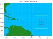
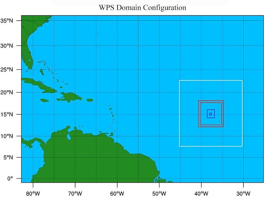
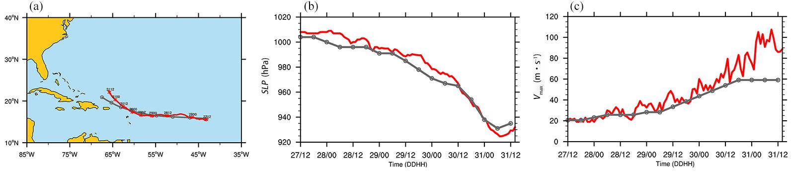
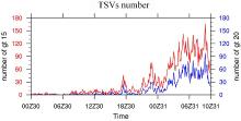
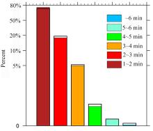
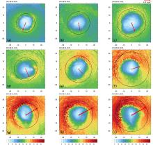
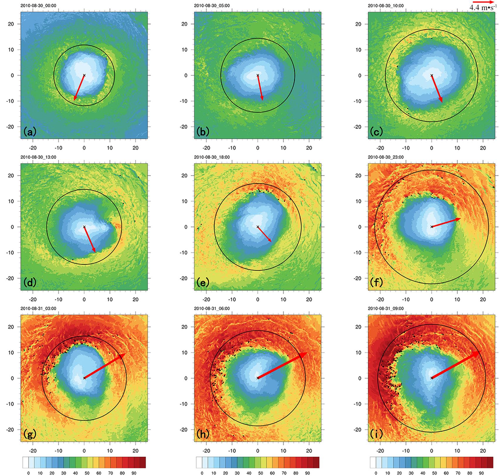
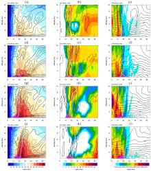
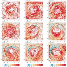
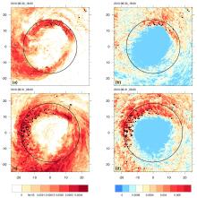
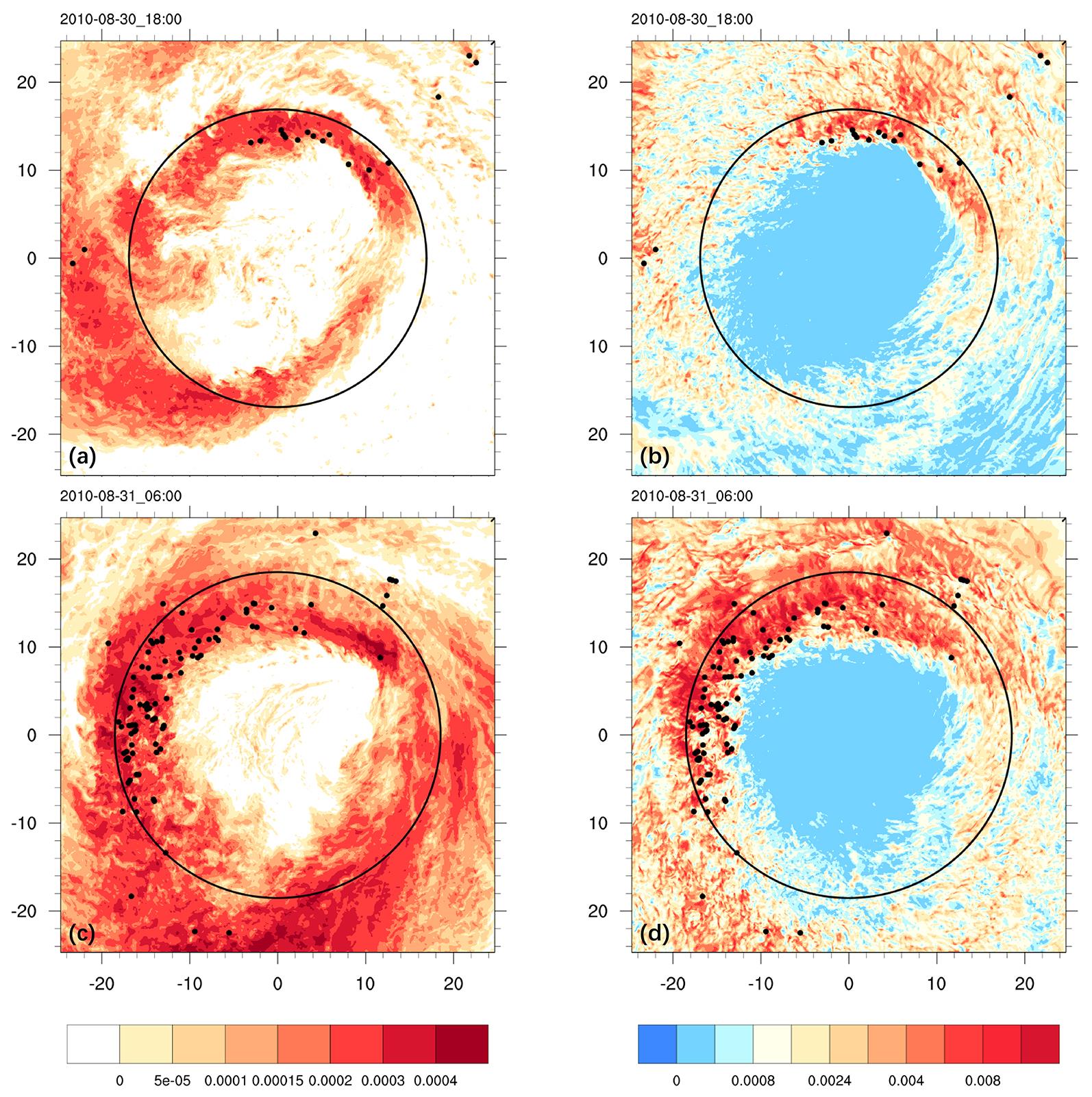
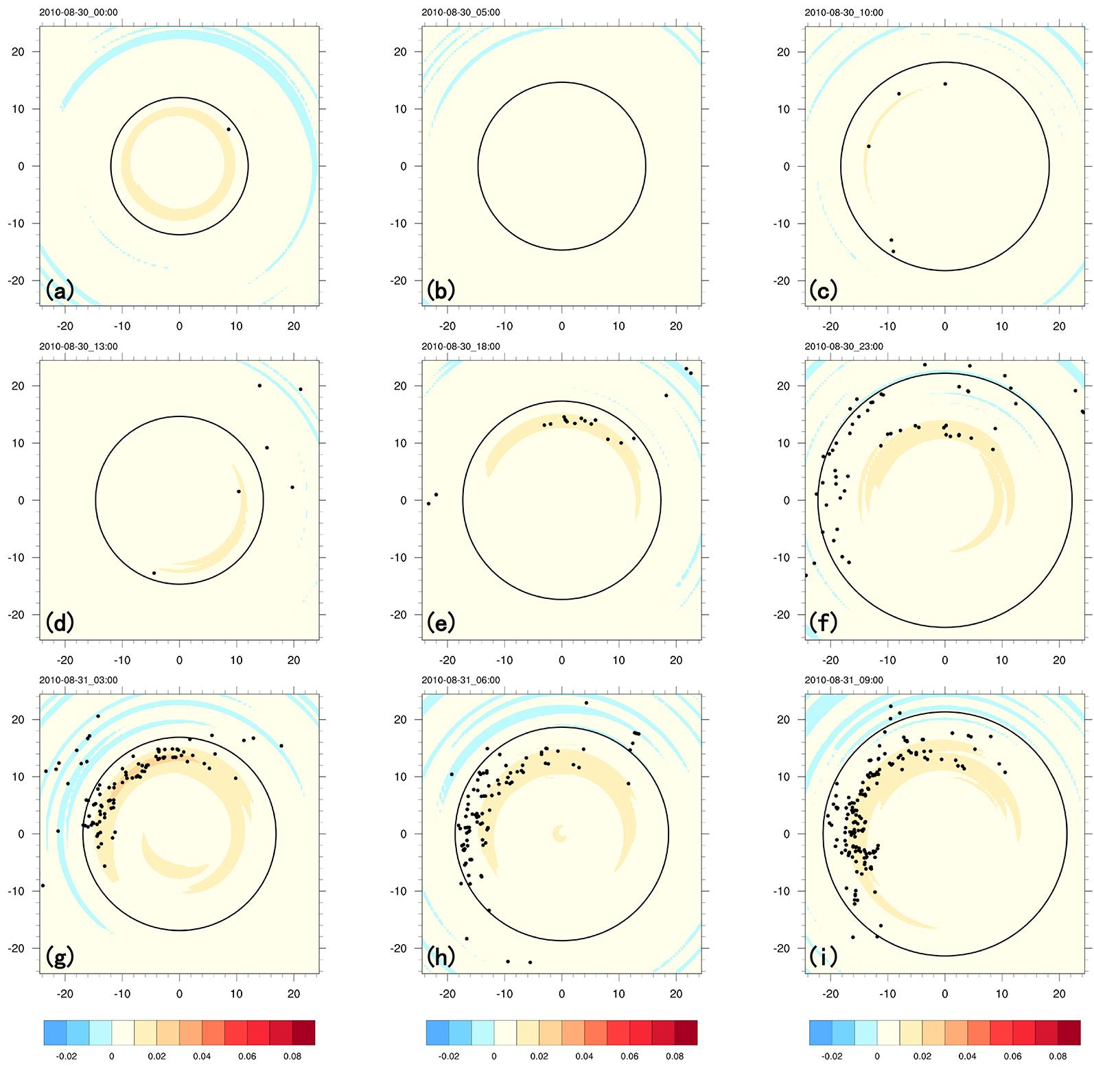
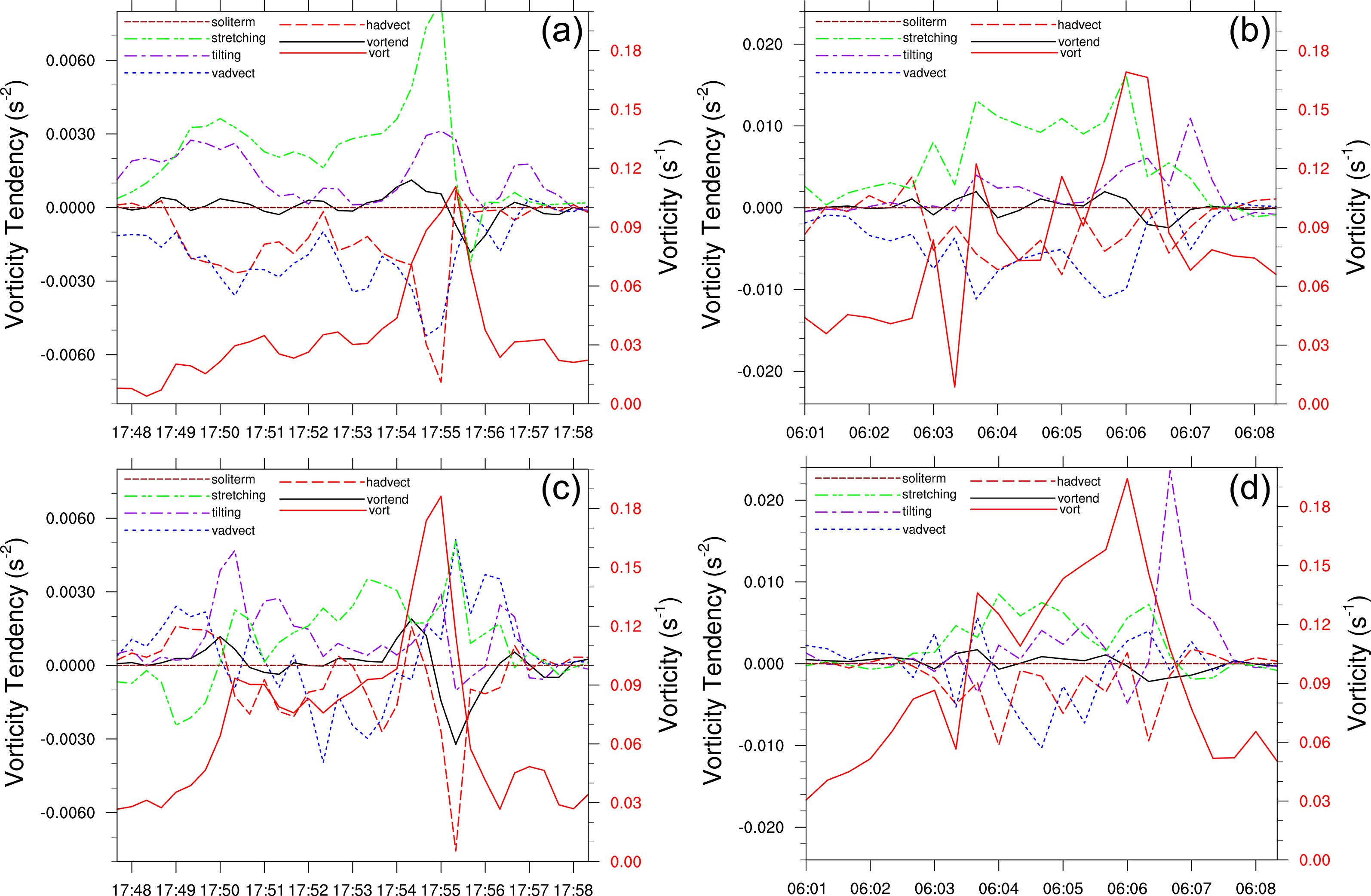
观测发现热带气旋(TC)边界层中存在龙卷尺度涡旋(TSV),其引起的相关阵风对近地面具有强烈影响.利用WRF?ARW模型,通过对飓风Earl (2010)进行高分辨率的数值试验模拟,分析了TC边界层龙卷尺度涡旋的时空分布特征以及发生发展的可能原因.Earl发展增强过程中,TSV数量随着Earl强度的增强而增加,尤其在最强期间表现最为活跃,一方面TC的增强提供了更强的背景场使得TSV更易生成,另一方面更强的背景场使得长生命期的TSV增加,每一时刻同时存在的TSV也就更多.TSV生成区域随Earl的发展从垂直风切左侧逐渐集中至逆风切左侧,且始终位于RMW内侧近地层次级环流上升支和最大垂直涡度位置附近,这里通常满足垂直切变和水平切变不稳定的必要条件,TSV涡度收支分析的结果表明,对TSV生成发展起主要贡献的是与水平风水平切变相关的拉伸项以及与垂直切变相关的扭转项,这意味着TSV的生成与发展可能与垂直切变不稳定和水平切变不稳定有关.
中图分类号:
- AP444


| 1 | Kossin J P, Schubert W H. Mesovortices,polygonal flow patterns,and rapid pressure falls in hurricane?like vortices. Journal of the Atmospheric Sciences,2001,58(15):2196-2209. |
| 2 | Kossin J P, Schubert W H. Mesovortices in hurricane Isabel. Bulletin of the American Meteorological Society,2004,85(2):151-153. |
| 3 | Hendricks E A, Montgomery M T. Rapid scan views of convectively generated mesovortices in sheared tropical cyclone Gustav (2002). Weather and Forecasting,2006,21(6):1041-1050. DOI:10.1175/WAF950.1 . |
| 4 | Aberson S D, Halverson J B. Kelvin–Helmholtz billows in the eyewall of hurricane Erin. Monthly Weather Review,2006,134(3):1036-1038. |
| 5 | Reasor P D, Montgomery M T, Marks F D,et al. Low?wavenumber structure and evolution of the hurricane inner core observed by airborne dual?Doppler radar. Monthly Weather Review,2000,128(6):1653-1680. |
| 6 | Wingo S M, Knupp K R. Kinematic structure of mesovortices in the eyewall of hurricane Ike (2008) derived from ground?based dual?Doppler analyses. Monthly Weather Review,2016,144(11):4245-4263. DOI:10.1175/MWR-D-16-0085.1 . |
| 7 | Shimada U, Horinouchi T. Reintensification and eyewall formation in strong shear:A case study of typhoon Noul (2015). Monthly Weather Review,2018,146(9):2799-2817. DOI:10.1175/MWR-D-18-0035.1 . |
| 8 | Stern D P, Bryan G H, Aberson S D. Extreme low?level updrafts and wind speeds measured by dropsondes in tropical cyclones. Monthly Weather Review,2016,144(6):2177-2204. DOI:10.1175/MWR-D-15-0313.1 . |
| 9 | Black P G, Marks F D. The structure of an eyewall meso?vortex in hurricane Hugo (1989)∥Preprints,19th Conference on Hurricanes and Tropical Meteorology. Miami,FL,USA:American Meteorological Society,1991:579-582. |
| 10 | Marks F D, Black P G, Montgomery M T,et al. Structure of the eye and eyewall of hurricane Hugo (1989). Monthly Weather Review,2008,136(4):1237-1259. DOI:10.1175/2007MWR2073.1 . |
| 11 | Aberson S D, Zhang J A, Ocasio K N. An extreme event in the eyewall of hurricane Felix on 2 September 2007. Monthly Weather Review,2017,145(6):2083-2092. DOI:10.1175/MWR-D-16-0364.1 . |
| 12 | Alford A A, Biggerstaff M I, Carrie G D,et al. Near?surface maximum winds during the landfall of hurricane Harvey. Geophysical Research Letters,2019,46(2):973-982. |
| 13 | Wurman J, Kosiba K. The role of small?scale vortices in enhancing surface winds and damage in hurricane Harvey (2017). Monthly Weather Review,2018,146(3):713-722. |
| 14 | Fernández?Cabán P L, Alford A A, Bell M J,et al. Observing hurricane Harvey's eyewall at landfall. Bulletin of the American Meteorological Society,2019,100(5):759-775. DOI:10.1175/BAMS-D-17-0237.1 . |
| 15 | Wakimoto R M, Black P G. Damage survey of hurricane Andrew and its relationship to the eyewall. Bulletin of the American Meteorological Society,1994,75(2):189-200. |
| 16 | Willoughby H E, Black P G. Hurricane Andrew in Florida:Dynamics of a disaster. Bulletin of the American Meteorological Society,1996,77(3):543-549. |
| 17 | Montgomery M T, Vladimirov V A, Denissenko P V. An experimental study on hurricane mesovortices. Journal of Fluid Mechanics,2002,471:1-32. DOI:10.1017/S0022112002001647 . |
| 18 | Mashiko W. Polygonal eyewall and mesovortices structure in a numerically simulated typhoon Rusa. SOLA,2005,1:29-32. DOI:10.2151/sola.2005-009 . |
| 19 | Nolan D S, Zhang J A, Stern D P. Evaluation of planetary boundary layer parameterizations in tropical cyclones by comparison of in situ observations and high?resolution simulations of hurricane Isabel (2003). Part I:Initialization,maximum winds,and the outer?core boundary layer. Monthly Weather Review,2009,137(11):3651-3674. DOI:10.1175/2009MWR2785.1 . |
| 20 | Nolan D S, Zhang J A, Uhlhorn E W. On the limits of estimating the maximum wind speeds in hurricanes. Monthly Weather Review,2014,142(8):2814-2837. DOI:10.1175/MWR-D-13-00337.1 . |
| 21 | Wu L G, Liu Q Y, Li Y B. Prevalence of tornado?scale vortices in the tropical cyclone eyewall. Proceedings of the National Academy of Sciences of the United States of America,2018,115(33):8307-8310. DOI:10.1073/pnas.1807217115 . |
| 22 | Wu L G, Liu Q Y, Li Y B. Tornado?scale vortices in the tropical cyclone boundary layer:Numerical simulation with the WRF–LES framework. Atmospheric Chemistry and Physics,2019,19(4):2477-2487. |
| 23 | Stern D P, Bryan G H. Using simulated dropsondes to understand extreme updrafts and wind speeds in tropical cyclones. Monthly Weather Review,2018,146(11):3901-3925. |
| 24 | Ito J, Oizumi T, Niino H. Near?surface coherent structures explored by large eddy simulation of entire tropical cyclones. Scientific Reports,2017,7(1):3798. DOI:10.1038/s41598-017-03848-w . |
| 25 | Cangialosi J P. Tropical cyclone report:Hurricane Earl,25 August–4 September 2010∥The National Hurricane Center and Central Pacific Hurricane Center's Tropical Cyclone Reports,2011. . |
| 26 | Kain J S, Fritsch J M. Convective parameterization for mesoscale models:The Kain–Fritsch scheme∥Emanuel K A,Raymond D J. The Representation of Cumulus Convection in Numerical Models. Boston,MA,USA:American Meteorological Society,1993:165-170. |
| 27 | Thompson G, Field P R, Rasmussen R M,et al. Explicit forecasts of winter precipitation using an improved bulk microphysics scheme. Part Ⅱ:Implementation of a new snow parameterization. Monthly Weather Review,2008,136(12):5095-5115. DOI:10.1175/2008MWR2387.1 . |
| 28 | Dudhia J. Numerical study of convection observed during the winter monsoon experiment using a mesoscale two?dimensional model. Journal of the Atmospheric Sciences,1989,46(20):3077-3107. |
| 29 | Mlawer E J, Taubman S J, Brown P D,et al. Radiative transfer for inhomogeneous atmospheres:RRTM,a validated correlated?k model for the longwave. Journal of Geophysical Research:Atmospheres,1997,102(D14):16663-16682. DOI:10.1029/97JD00237 . |
| 30 | Jiménez P A, Dudhia J, González?Rouco J F,et al. A revised scheme for the WRF surface layer formulation. Monthly Weather Review,2012,140(3):898-918. DOI:10.1175/MWR-D-11-00056.1 . |
| 31 | Brown B R, Bell M M, Frambach A J. Validation of simulated hurricane drop size distributions using polarimetric radar. Geophysical Research Letters,2016,43(2):910-917. DOI:10.1002/2015GL067278 . |
| 32 | Wu D, Zhang F Q, Chen X M,et al. Evaluation of microphysics schemes in tropical cyclones using polarimetric radar observations:Convective precipitation in an outer rainband. Monthly Weather Review,2021,149(4):1055-1068. DOI:10.1175/MWR-D-19-0378.1 . |
| 33 | Shin H H, Hong S Y. Representation of the subgrid?scale turbulent transport in convective boundary layers at gray?zone resolutions. Monthly Weather Review,2015,143(1):250-271. DOI:10.1175/MWR-D-14-00116.1 . |
| 34 | Chen X M, Xue M, Zhou B W,et al. Effect of scale?aware planetary boundary layer schemes on tropical cyclone intensification and structural changes in the gray zone. Monthly Weather Review,2021,149(7):2079-2095. DOI:10.1175/MWR-D-20-0297.1 . |
| 35 | Smagorinsky J. General circulation experiments with the primitive equations. I. The basic experiment. Monthly Weather Review,1963,91(3):99-164. |
| 36 | Kaplan J, DeMaria M. Large?scale characteristics of rapidly intensifying tropical cyclones in the north Atlantic Basin. Weather and Forecasting,2003,18(6):1093-1108. DOI:10.1175/1520-0434(2003)018<1093:LCORIT>2.0.CO;2 . |
| 37 | Miyamoto Y, Nolan D S. Structural changes preceding rapid intensification in tropical cyclones as shown in a large ensemble of idealized simulations. Journal of the Atmospheric Sciences,2018,75(2):555-569. DOI:10.1175/JAS-D-17-0177.1 . |
| 38 | Susca?Lopata G, Zawislak J, Zipser E J,et al. The role of observed environmental conditions and precipitation evolution in the rapid intensification of hurricane Earl (2010). Monthly Weather Review,2015,143(6):2207-2223. DOI:10.1175/MWR-D-14-00283.1 . |
| 39 | Miles J W. On the stability of heterogeneous shear flows. Journal of Fluid Mechanics,1961,10(4):496-508. DOI:10.1017/S0022112061000305 . |
| [1] | 赵熠轩, 仇欣, 王其伟. 登陆我国内陆热带气旋的衰减趋势分析[J]. 南京大学学报(自然科学版), 2024, 60(2): 257-266. |
| [2] | 赵睿峰, 谈哲敏, 雷荔傈. 热带气旋边界层的全息希尔伯特谱分析[J]. 南京大学学报(自然科学版), 2020, 56(5): 601-615. |
| [3] | 禹梁玉,方娟**. 台风随"鲇鱼”(2010)过程影响系统分析*[J]. 南京大学学报(自然科学版), 2013, 49(3): 285-299. |
| [4] | 李力,江静**,周洋. 全球变暖背景下西北太平洋热带气旋活动的气候特征*[J]. 南京大学学报(自然科学版), 2012, 48(2): 228-235. |
| [5] | 曹 勇, 江 静 ** . 台风季中国热带气旋降水的典型模态及显著影响因子* [J]. 南京大学学报(自然科学版), 2011, 47(1): 60-70. |
| [6] | 杜予罡, 储惠芸** . 环境因子对西北太平洋热带气旋气候特征的影响* [J]. 南京大学学报(自然科学版), 2010, 46(3): 254-260. |
| [7] | 宋金杰 , 王 元 . 西北太平洋变性热带气旋的若干特征 [J]. 南京大学学报(自然科学版), 2010, 46(3): 328-336. |
|
||